


Darbun Voting District, Marion County, Mississippi
About
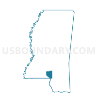
Outline

Summary
| Unique Area Identifier | 606221 |
| Name | Darbun Voting District |
| County | Marion County |
| State | Mississippi |
| Area (square miles) | 19.73 |
| Land Area (square miles) | 19.72 |
| Water Area (square miles) | 0.01 |
| % of Land Area | 99.94 |
| % of Water Area | 0.06 |
| Latitude of the Internal Point | 31.29383650 |
| Longtitude of the Internal Point | -90.00329900 |
Maps


Graphs
Select a template below for downloading or customizing gragh for Darbun Voting District, Marion County, Mississippi


Neighbors
Neighoring Voting District (by Name) Neighboring Voting District on the Map
- Darbun Voting District, Walthall County, MS
- Morgantown Voting District, Marion County, MS
- Stoval Voting District, Marion County, MS
- Tilton Voting District, Lawrence County, MS
- White Bluff Voting District, Marion County, MS
Top 10 Neighboring County Subdivision (by Population) Neighboring County Subdivision on the Map
- District 3, Marion County, MS (5,405)
- District 4, Walthall County, MS (3,259)
- District 3, Lawrence County, MS (2,845)
Top 10 Neighboring Unified School District (by Population) Neighboring Unified School District on the Map
- Marion County School District, MS (16,230)
- Walthall County School District, MS (15,443)
- Lawrence County School District, MS (12,929)
Top 10 Neighboring State Legislative District Lower Chamber (by Population) Neighboring State Legislative District Lower Chamber on the Map
- State House District 99, MS (26,927)
- State House District 100, MS (25,804)
- State House District 97, MS (25,156)
Top 10 Neighboring State Legislative District Upper Chamber (by Population) Neighboring State Legislative District Upper Chamber on the Map
Top 10 Neighboring 111th Congressional District (by Population) Neighboring 111th Congressional District on the Map
Top 10 Neighboring Census Tract (by Population) Neighboring Census Tract on the Map
- Census Tract 9501, Walthall County, MS (7,063)
- Census Tract 9603, Lawrence County, MS (4,129)
- Census Tract 9502, Marion County, MS (3,658)